Potential Tropical Cyclone 6 is in the Gulf; Heavy rain expected
TROPICAL OUTLOOK:The National Hurricane Center has officially identified Potential Tropical Cyclone Six in the Gulf of Mexico. The system is in the southwestern Gulf of Mexico and will be moving north along the Mexico and Texas coastline. It will eventually bring very heavy rain to southeast Louisiana for several days this week. CURRENT ALERTS:Tropical storm watches have been issued along the coast of Texas. LIKELIEST PATH:Forecast data for where the storm will track are in fairly good agreement forecasting its projected path. Most of the data is clustered around a track that will take the system just off the coasts of Northern Mexico and Texas, then turn northeast and make landfall in Louisiana.TIMING:Tropical Storm force winds are likeliest to arrive by midday Wednesday.LOCAL IMPACTS:The track now has this storm moving more east, meaning more of an impact on southeast Louisiana. WIND: Forecast data right now shows possible wind gusts as high as 50-60 mph across the area.STORM SURGE:Data shows possible waves between 10-15 feet. This would indicate that a significant storm surge is likely.STORM TIMING:Forecast data is consistent with Wednesday being the most likely day to bring the most impacts, but some of the data shows the storm bleeding well into Thursday as well.Storms are forecast to be most numerous Wednesday and will also contain a threat for tornadoes.This same forecast shows powerful storms and winds into early Thursday morning, too.RAINFALL:Flooding could be our greatest concern after a couple of recent heavy rain events in the past two weeks.Forecasters are calling for widespread totals of 3-5 inches with locally higher amounts.At this time, we are confident this storm will become a tropical storm and, at least, a Category 1 hurricane. Since intensity forecasts are notorious for being conservative, it’s possible it could become an even stronger hurricane before it makes landfall.Take time now to make sure you’ve got everything you need to withstand several days of possible power outages. Most importantly, be sure to follow each and every update here so if evacuation is needed you can head out as early as possible.The entire WDSU First Warning Weather Team will continue to provide you with all the latest information on this storm.
TROPICAL OUTLOOK:
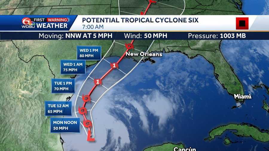
The National Hurricane Center has officially identified Potential Tropical Cyclone Six in the Gulf of Mexico. The system is in the southwestern Gulf of Mexico and will be moving north along the Mexico and Texas coastline. It will eventually bring very heavy rain to southeast Louisiana for several days this week.
CURRENT ALERTS:
Tropical storm watches have been issued along the coast of Texas.
LIKELIEST PATH:
Forecast data for where the storm will track are in fairly good agreement forecasting its projected path. Most of the data is clustered around a track that will take the system just off the coasts of Northern Mexico and Texas, then turn northeast and make landfall in Louisiana.
TIMING:
Tropical Storm force winds are likeliest to arrive by midday Wednesday.
LOCAL IMPACTS:
The track now has this storm moving more east, meaning more of an impact on southeast Louisiana.
WIND:
Forecast data right now shows possible wind gusts as high as 50-60 mph across the area.
STORM SURGE:
Data shows possible waves between 10-15 feet. This would indicate that a significant storm surge is likely.
STORM TIMING:
Forecast data is consistent with Wednesday being the most likely day to bring the most impacts, but some of the data shows the storm bleeding well into Thursday as well.
Storms are forecast to be most numerous Wednesday and will also contain a threat for tornadoes.
This same forecast shows powerful storms and winds into early Thursday morning, too.
RAINFALL:
Flooding could be our greatest concern after a couple of recent heavy rain events in the past two weeks.
Forecasters are calling for widespread totals of 3-5 inches with locally higher amounts.
At this time, we are confident this storm will become a tropical storm and, at least, a Category 1 hurricane. Since intensity forecasts are notorious for being conservative, it’s possible it could become an even stronger hurricane before it makes landfall.
Take time now to make sure you’ve got everything you need to withstand several days of possible power outages. Most importantly, be sure to follow each and every update here so if evacuation is needed you can head out as early as possible.
The entire WDSU First Warning Weather Team will continue to provide you with all the latest information on this storm.


