A once-in-1,000 year rainfall event from an unnamed storm is flooding homes and forcing rescues in North Carolina | CNN
CNN
—
Floodwater surged into homes, stranded vehicles and forced water rescues in coastal North Carolina on Monday after a tropical storm-like system dumped historic amounts of rain in a matter of hours.
“It’s probably the worst flooding that any of us have seen in Carolina Beach,” Town Manager Bruce Oakley told CNN of the tourist town not far from Wilmington. “We’ve had to rescue people from cars, also some from houses and businesses.”
Emergency services fielded dozens of calls for rescue, Oakley added.
Carolina Beach was placed under a state of emergency Monday after a “historic” 18 inches of rain fell there in 12 hours at one station, a once-in-1,000-year rainfall event, according to the National Weather Service in Wilmington. More than a foot of rain in 12 hours was reported elsewhere in the area, a once-in-200-year rain event.
Carolina Beach Elementary School was closed and students were dismissed early after classrooms started to flood, Oakley confirmed. Law enforcement and fire crews helped take some children home as some routes to the school were impassible due to the flooding, with roads under 3 feet of water.
The owner of The Fat Pelican in Carolina Beach told CNN affiliate WWAY he didn’t have time to prepare for that much water.
“There’s water inside the building. I’m trying to get the stuff that was outside that floated away,” Michael McLaughlin explained. But, he said he was optimistic that after the storm passed he could take a garden hose, wash the inside of the restaurant thoroughly and they’d “be ready to go again.”
Lisa and Gary Hollon have had a home in Kure Beach, about 3 miles south of Carolina Beach, for nearly 15 years and never experienced flooding until Monday.
The winds and rain picked up in the early hours of the morning and the first floor of their home experienced “sudden flooding of 4 to 6 inches,” Lisa Hollon told CNN.
“We were not prepared and have never flooded before,” she said. “Many cars were unexpectedly flooded in driveways and along roads.”
In video shared with CNN, the road outside of the home is covered by water as vehicles slowly drive by, causing ripples.
Flooding also ramped up in neighboring Brunswick County where rainfall rates exceeded 4 to 5 inches per hour for a time Monday. The town of Sunny Point picked up more than a month’s worth of rain when over 9 inches fell in just three hours.
“Our deputies are assisting multiple people who are stranded in their vehicles and some homes at this time,” the Brunswick County Sheriff’s office said on Facebook.
The city of Southport posted on Facebook on Monday afternoon that a shelter-in-place order was in effect and later added there was a curfew between 9 p.m. and 7 a.m.
In the Brunswick County, North Carolina, community of Supply, Timothy Turner used his surfboard to travel after the road next to his house was destroyed by flooding. In some areas, the water would have been over his head.
After Supply – about 10 miles from Holden Beach – was hit by intense rain, Turner offered to help a neighbor whose dog was stuck at home on the other side of the road.
“I crossed it with my surfboard, sank down into the mud, went to her house, got her dog and brought it back across,” said Turner, who runs a surfing school and assists with ocean rescues since the area doesn’t have lifeguards.
“I’ve gotten 25 rescues out of the rip currents in the last eight years but that was the first time I ever got a dog up with a surfboard.”
The extreme rainfall and flooding is another stark reminder that it doesn’t take a named storm to trigger extremely dangerous conditions. The atmosphere was ripe to unload torrential rainfall, something that’s becoming more common as the world warms due to fossil fuel pollution.
Floodwaters started to recede in Carolina Beach early Monday afternoon as torrential rain shifted west of the area, according to Oakley. But cars abandoned during the worst of the flooding remained on empty roadways, according to town mayor Lynn Barbee.
Storm is weakening and forecast is improving
Tropical storm warnings for the coastal Carolinas have been discontinued as of Monday evening, according to the National Hurricane Center.
The system was called Potential Tropical Cyclone Eight because it wasn’t organized enough to be dubbed a tropical or subtropical storm.
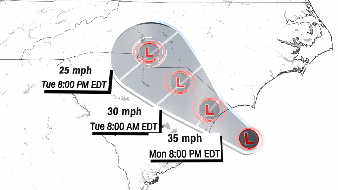
“Continued weakening is expected during the next day or so, and the low is forecast to dissipate over the Carolinas by early Wednesday,” forecasters said.
A system’s center is typically where its strongest winds and its heaviest rain occur, but that’s not the case for Potential Tropical Cyclone Eight. Most of the system’s heaviest rain and gusty winds are far removed from its poorly defined center, satellite imagery shows.
The center of the system came ashore Monday evening near the South Carolina-North Carolina state line, with southeast North Carolina still enduring most of the storm’s significant impacts.

Much of southeast North Carolina is under a flood watch until Tuesday morning, according to the National Weather Service.
“Excessive runoff may result in flooding of rivers, creeks, streams, and other low-lying and flood-prone locations. Creeks and streams may rise out of their banks. Flooding may occur in poor drainage and urban areas,” forecasters said. They said less than an inch of additional rainfall could come down in the area Monday night but there is only a 20% chance of rain Tuesday.
The Carolinas were deluged by 6 to 12 inches of rainfall from Debby in early August that created a flash flood emergency near Charleston, South Carolina.
CNN Meteorologists Elisa Raffa and Brandon Miller and Jillian Sykes contributed to this report.
