Milton expected to become major hurricane on Monday. Here’s what Florida can expect.
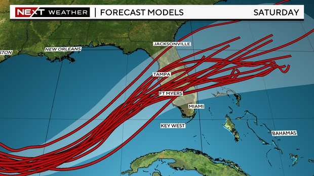
MIAMI — Milton is now a Category 1 hurricane after forming as a tropical storm in the western Gulf of Mexico on Saturday and continues strengthening as it approaches Florida’s Gulf Coast.
The National Hurricane Center said its hurricane hunters are finding Milton “rapidly intensifying” and that the storm is expected to become a major Category 4 or 5 hurricane on Monday in the Central Gulf.
It is forecasted to become a Category 3 hurricane before making landfall across the west coast of Florida on Wednesday.
On Saturday evening, Governor Ron DeSantis declared a state of emergency in 35 counties ahead of Milton’s landfall. In the state of emergency bulletin, DeSantis included Broward, Miami-Dade and Monroe Counties. That number has now increased to 51 counties.
How will Milton impact South Florida?
CBS News Miami’s NEXT Weather Team said the track has shifted a little north on Saturday evening toward Tampa and Fort Myers, but it still includes some portions of South Florida, including Broward County. The storm will be slow to move and organize overnight Sunday before it is expected to speed up and intensify on between Monday and Tuesday.
South Florida will receive a “one-two punch” with this system, beginning Sunday with a weaker and non-tropical area of low pressure that will swing through the area then and into Monday. This will bring South Florida’s first round of heavy rain and potential flooding. By Tuesday, there will be a slight break with a few storms across the area.
The second “punch” will be Milton, forecasted to arrive at the Gulf Coast on Wednesday afternoon, bringing more heavy rain and windy weather.
Depending on its track, Milton could bring tropical-storm conditions very early Wednesday for most of South Florida; however, the Florida Keys could see these conditions earlier.
For now, South Florida’s main threat continues to be the risk of rainwater flooding, with 4″-7″+ looking likely across the area.
Saturday will be a precursor to this stretch of very wet weather, with ongoing rounds of showers and storms set to move through the area. This will prime Florida soils for what will likely be an increasing flood risk set to continue into the week ahead. Expect a flood watch to take effect through Thursday.
Remember: if you see standing water on the roadways, turn around because it only takes a foot of water to float most vehicles.
NEXT Weather Radar


